Remains of a historic wall, reference LHL086
LHL086
Published on Thursday, September 4.
Updated on Friday, September 12.
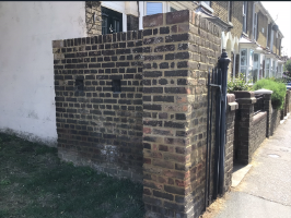
A short length of stock brick wall, constructed in 1940 in anticipation of the German invasion and located to defend the main Eastern entrance into Faversham at its most constricted point – the now demolished railway bridge across the Whitstable Road. On its Western face the wall incorporates the remains of 3 deliberately angled rifle positions, now blocked. This wall is a rare and nationally significant survival of emergency defensive measures undertaken throughout the Southern England, under direction of the Wartime Coalition Government. Nationally, most similar defences have been demolished. It should be noted this wall also retains the last remains of a cast iron pier and railings standards, dating from the early 20th Century, of the Faversham Borough Council’s Cattle Market entrance. A second, longer section of the same railings remains nearby, at the West side of the entrance to Bob Amor Close.
Location
Shooting Gallery Wall and Cattle Market Railings at Junction of Whitstable Road with Bob Amor Close, Faversham
You can view LHL086 on our interactive map.
You can see the location of LHL086 on a map.
Type of structure
LHL086 is a remains of a historic wall.
Associated images
There is 1 image associated with LHL086:
Share this page