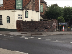
Remains of a historic wall, reference LHL087
LHL087
Published on Thursday, September 4.
Updated on Thursday, September 4.
A curved length of stock brick wall, constructed in 1940 in anticipation of the German invasion and located to defend the main road leading to Chatham and London at the point where the A2 descends into Ospringe and becomes more vulnerable to rifle fire. The wall masquerades as a boundary wall but incorporates the angled remains of two angled rifle positions. This wall is a rare and nationally significant survival of emergency defensive measures undertaken throughout Southern England, under the direction of the Wartime Coalition Government. Nationally, most similar defences have been demolished.
Location
Defensive brick wall at the corner of the A2 with Ospringe Road (i.e.. at The Ship Inn), Faversham
You can view LHL087 on our interactive map.
You can see the location of LHL087 on a map.
Type of structure
LHL087 is a remains of a historic wall.
Associated images
There is 1 image associated with LHL087:
Share this page