Remains of a historic wall, reference LHL090
LHL090
Published on Thursday, September 4.
Updated on Friday, September 12.
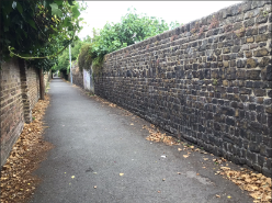
A much varied mixture of red and yellow brick and flint & pebble, single height walls enclosing the North and South sides of the Lane and of mixed late 18th - late 19th Century dates .The walls on both sides incorporate a considerable number of pedestrian gateways, some with brick arches, others with capped piers, and many of which have been bricked up. The brickwork has been laid in various bonds, both regular and irregular. The Lane is significant for Faversham as the manifestation of a late 18th/early 19th Century ropery but the changing pattern of walls, gates and piers also tells much about the historic ownerships, land boundaries and development pattern of this area of Faversham over a 200 year period. The whole collection has important townscape value.
Location
Boundary Walls enclosing Cross Lane between South Road and Bank Street. (former ropery line), Faversham
You can view LHL090 on our interactive map.
You can see the location of LHL090 on a map.
Type of structure
LHL090 is a remains of a historic wall.
Associated images
There is 1 image associated with LHL090:
Share this page